The Sierra Nevada: Wildfires in the Wilderness
Fire in California has a split personality
![The Creek Fire soon after it started in September 2020. In all, four million acres of land burned in California last year. (Clovis [California] Fire Department)](https://theamericanscholar.org/wp-content/uploads/2021/02/Wheelwright-FEATURED-1024x538.jpg "Wheelwright FEATURED")
Ponderosa Way sounds like an address in a faux-sylvan California subdivision, a street you might imagine next to Redwood Lane and Happy Brook Drive. More than a dozen Ponderosa Ways dot the woodsy western flank of the Sierra Nevada range, each about an hour’s drive from the bustle and smog of the Central Valley. Ponderosa Way near Rich Gulch, for instance, winds through an old gold-mining area east of Stockton. Ponderosa Way in Heather Glen, 50 miles north, lies in commuting distance of Sacramento, the capital.
Go another 60 miles north as the crow flies and you come to Ponderosa Way in Magalia—but that is a sad place ever since this tiny community was nearly incinerated two and a half years ago. The Camp Fire of 2018, which blackened Magalia and nearby Paradise, killing 85 people, remains the most destructive wildfire in state history, yet in terms of the acreage burned, it ranks far below the large fires on the hellscape of 2020.
The original Ponderosa Way was a continuous line running roughly north and south, connecting Magalia and other communities in the Sierra foothills. Bulldozed in 1933–34 across canyons and wild rivers, it was a 650-mile-long open strip and truck road, technically known as a fuel break. With wildfires on the increase in the 20th century, the Ponderosa Way was meant to be California’s line in the sand between the settled areas in the Central Valley and the vast and flammable Sierra timberland. The line was strategic, a base from which to combat fires advancing from either the woods above or the brushlands below. But the strip was soon neglected, breached, chopped up by development, and eventually erased as Californians moved higher into the backcountry, leaving behind eponymous reminders on street signs. The abandonment of the Ponderosa Way tells you just about all you need to know about the fires raging in California in 2020.
Wildfire specialists, a consortium that includes forest managers, academic researchers, and boots-on-the-ground rangers, these days grapple with a different concept than a long firebreak. The buzzword is wildland-urban interface, or WUI. In the western Sierra, WUI represents the places, both lower and higher than Ponderosa Way, where human habitation and development meet raw brush and timber. “It’s a dumb name,” writes fire historian Stephen J. Pyne in an essay for the website The Conversation, “because the boundary is not really an interface but an intermix, in which houses and natural vegetation abut and scramble in an ecological omelet. … Think of these areas not as wildlands encumbered by houses, but as urban or exurban enclaves with peculiar landscaping.”
WUI characterizes the smaller Coast Range on the western side of the Central Valley, and the arid mountains near Los Angeles and San Diego. Those ranges lack the grand coniferous weight, the sugar pines and sequoias, of the Sierra forests. Firefighters have been playing a giant game of Whac-A-Mole in the Sierra. Dropped from helicopters and racing hither and yon, they are able to save many structures and most lives. They win battles against fire but are losing the overall war because the conflagrations have only become bigger.
Is climate change to blame? Warming temperatures are undeniable and will continue, and so too the downslope winds, which erupt violently and fan flames, but climate change is not the main factor in the terrible fires of recent years. Although heat and wind aggravate the destructive potential of fire, the underlying causes are longstanding.
The fundamental problems are the steady growth of the human presence in the mountains and the simultaneous growth of fuel for the fires. Early in the 20th century, the Sierra forest was penetrated by stockmen, who led cattle, sheep, and goats into the high meadows, and by loggers, who felled the virgin stands of timber. Native Americans had left them an uncluttered and “naturally” managed forest, which included both regular, light burning conducted by the indigenous people and modest fires that lightning started. When, after a period of scrutiny, the practice of light burning was deemed unsafe and unscientific, the suppression of all fires became federal and state policy. The result has been a doubling of the woody biomass of brush and timber, which logging operations were not able to retard, creating more and more tinder for aggressive fires.
In the second half of the 20th century, the Sierra National Forest became less of a commodity and more of a vacationland. As logging and grazing declined, the more important resource was water from the winter snowfall. Scores of dams created lakes that generated hydroelectricity and stored water against the state’s notoriously dry summers. The roads to the reservoirs and to old logging yards and defunct mines attracted fishermen, campers, boaters, lakeside developers, hikers, and horseback riders. Meanwhile, the population of California increased from fewer than seven million people in the 1930s to nearly 40 million, most of whom live within a few hours’ drive of the mountains. The forest is bookended by two heavily visited national parks, Yosemite on the north and Sequoia & Kings Canyon on the south. The great majority of forest users are responsible, but a careless few can spark a lot of damage.
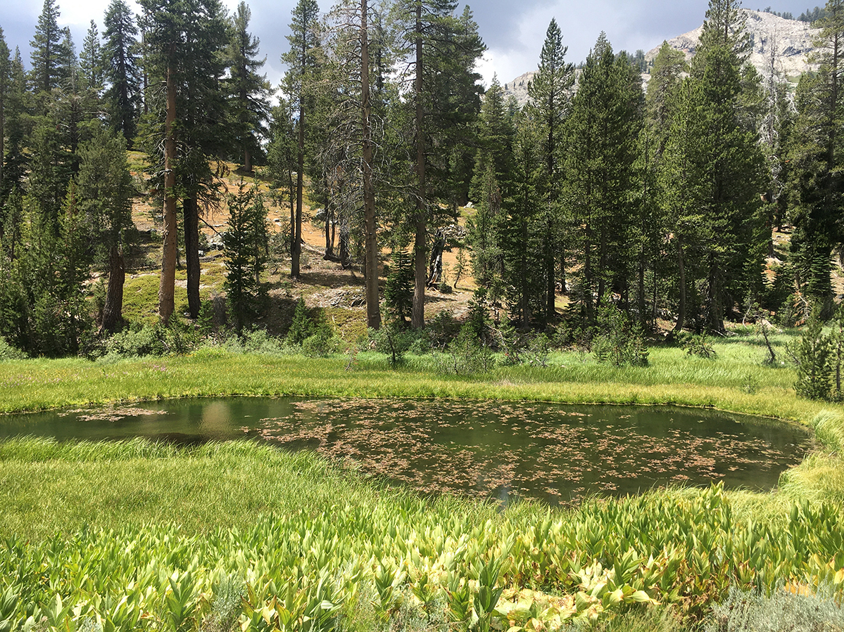
A pond in Stevenson Meadow in July, weeks before the Creek Fire approached. Trout streams thread the area. (Courtesy of the author)
I have backpacked in the Sierra forest nearly every summer for 20 years. Usually, I approach by the western foothills, past what remains of the Ponderosa Way, past the rustic lakeside cabins, and then up a single-lane road until it stops at the sharp, pale granite of the high country. The tallest pines and firs can be found in the middle elevations, the zone between 5,000 and 8,000 feet. These woods have looked ragged to me in recent years, and I have become nervous as I pass through them. A drought began in 2012, and by the time it ended in 2017, bark beetles had killed swaths of weakened trees. By some estimates, more than 100 million trees have died in the forest. Orange-needled hulks stand beside the road like huge matchsticks, flaunting their flammable tips. Fire on these twisting, narrow roads could easily block the escape routes.
Late last July, I drove to a trailhead a few miles south of the Ansel Adams Wilderness. At about 7,000 feet in elevation, this particular area was logged and mined in the recent past, and so the second-growth woods were dense. At one point, a bear barreled across the road, appearing and disappearing with a suddenness that wouldn’t have been possible in the original forest. Frequent light burning would have cleared the understory and opened the views.
I prefer the wilderness of the national forest to that of the nearby national parks because the visitors and amenities are fewer, and the oversight, to be frank, is slacker. The U.S. Forest Service spends so much of its budget on firefighting that it can’t afford the number of year-round rangers the Park Service has. After hiking a few miles from the trailhead, I passed beyond official supervision.
In Ansel Adams, the wilderness proper—the roadless, most remote part of the forest—begins at a rocky point called the Niche. An ample creek tumbles off it. If you had to, you could fight a fire from this promontory, or at least survive one. Refilling my water container, I plunged into the woods and continued north. Though the trail was shaded, damp, and splashed with wildflowers, the mosquitoes that I expected were few and far between, no doubt because of the dry winter. Snowfall last year was well below normal, the start perhaps of another California drought. In sun-filled breaks along the trail, I stepped across seasonal creeks that were dry.
I camped the first night above the gorge of the North Fork of the San Joaquin River. All three forks or tributaries of the river flow through the Ansel Adams Wilderness, and all are tapped by the Big Creek Hydroelectric Project, which tunnels water to six major reservoirs. The steep river lay out of sight 2,000 feet below me, and directly across, on the shoulder of a mountain, I noticed a rust-colored band of desiccated pine.
Hiking down the next day through groves of hemlock and red fir, I reached the North Fork and camped beside it. The name of this narrow place in the canyon is Hemlock Crossing. It features a thunderous waterfall, which feeds a swirling pool of very cold water, and just below that is a picturesque metal bridge. In the old days before the wilderness was designated, sheep men used this trail. A string of lush meadows, collectively called Stevenson Meadow, fringes the upper stretch of the river. Grassy pockets threaded with trout streams ascend almost to the tree line—to almost 10,000 feet, that is—where the truly alpine country starts.
I spent a couple of days exploring up and down the river while clearing my head of evil thoughts. Few other hikers came this far. Those who did were fast and young, for the most part, and could not pass without having to chat with me, the solo geezer, who was stationed like a troll by the bridge. When the time came, I happily shouldered my backpack and hiked back up the mountain toward home.
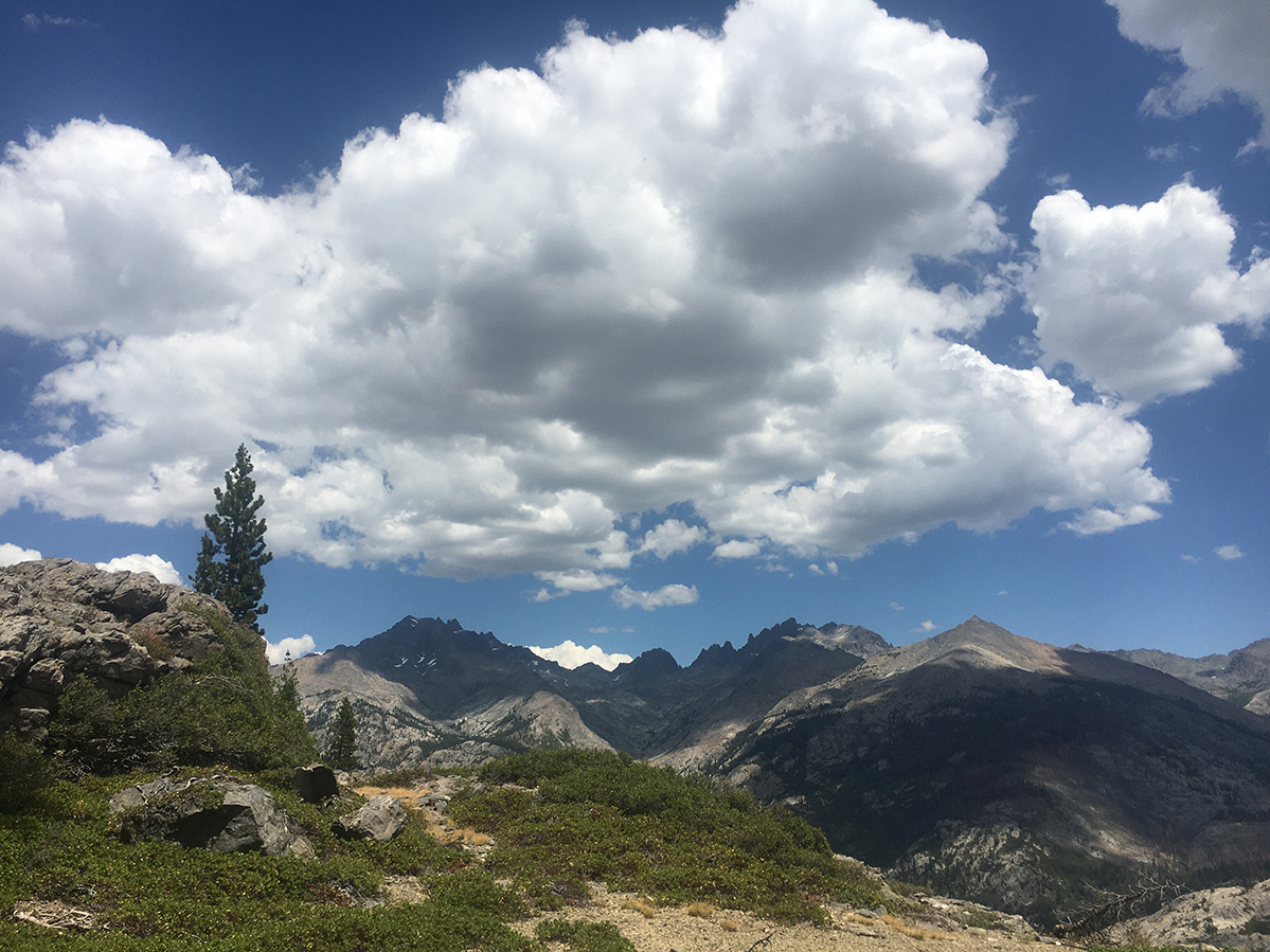
The Minarets formation shows in the center distance, looking from above the North Fork of the San Joaquin River. (Courtesy of the author)
A few weeks later, in mid-August, thunderstorms and lightning sparked large fires in both the Coast and the Sierra Nevada ranges. Though conditions were more than ripe, the instigation of the fires was unusual. In the modern era, lightning causes only five percent of wildfires in California; the rest have humans to thank, whether through accident or arson. The original Ponderosa Way owes its inception in part to arsonists. The Depression and the Dust Bowl had unloosed thousands of migrants who came to California looking for work. Some of the young men set fires in the forest, and the next morning, according to Stuart Show, the regional forester, the “same gang of homeless, jobless men would show up” seeking to be hired as firefighters. To create honest employment, the state established labor camps in the forest, and these in turn became part of the federal Civilian Conservation Corps, which constructed the Ponderosa Way.
Around six p.m. on September 4, 2020, a Friday, someone or something started a fire near Camp Sierra, a hamlet in the San Joaquin River drainage. The blaze blew up and spread extremely quickly. On Saturday, it destroyed half of the houses in nearby Big Creek, the hydroelectric center. So much fuel—dead and downed trees—was packed at the fire’s core that it shot a mushroom cloud of smoke into the stratosphere. To the west, hundreds of people were trapped at the Mammoth Pool reservoir. Overnight, National Guard helicopters plucked 224 people and ferried them to safety. Two days later, helicopters evacuated another 142 people from Edison Lake and China Peak. Well east of the fire, those stranded were mainly hikers who were not in imminent danger, but the road from the reservoir was blocked halfway down.
In just over a week, the Creek Fire, as it was dubbed, had burned 200,000 acres. Southwest of Edison Lake, the evacuated resort communities at Shaver Lake and Huntington Lake were severely damaged. Farther to the south, the fire tore through the ponderosa pines toward the village of Auberry and was stopped just three miles from the motel where I had stayed in July. At the height of the containment effort in September, some 2,000 men and women fought the fire. Bulldozers cleared fuel breaks (mini-Ponderosa Ways) while hand crews set backburns to rob the flames of fuel. Planes and helicopters dumped water and flame retardant. Smoke blanketed the region for hundreds of miles.
After torching 856 structures and scorching almost 380,000 acres, the Creek Fire became the largest single wildfire in the state’s history. (Three other blazes during 2020 were even larger but are considered “complexes” rather than single fires because they started from separate lightning strikes and then merged.) All told, more than four million acres burned in the state in 2020, a number that shatters all previous records.
Though the blaze was not fully extinguished until December, by October the emergency at the Creek Fire was over. Boxed in on three sides, the flames spread only to the north, into the Ansel Adams Wilderness. The fuels grew thinner; cooler nights dampened each day’s flareups. Slowly, almost contemplatively, the fire followed the tracks of my hike in July. Spotter planes flew over the northern perimeter, taking infrared readings through the smoke, and orbiting satellites detected new points of heat, so I could follow the fire’s progression on online maps. Every morning with coffee in hand, I zoomed in on the Stevenson Trail. I watched the fire chew its way over the Niche and nose up the canyon of the North Fork until it reached the bridge at Hemlock Crossing.
The fire managers did not seem worried. At the daily briefings in mid-October, the incident commanders waved at the map, acknowledged the fire’s “unstaffed edge,” said it was “crawling up into the rocks,” but nevertheless insisted that “full suppression” of the Creek Fire was the goal. At first, I was puzzled, because with little trouble hand crews could have been dropped into Stevenson Meadow, where they might contain the fire. Instead, the managers spoke of the hazardous terrain, the smoke, the threats to safety.
On the one hand, the agencies’ restraint was appropriate. For years, both official and unofficial policy has been to let wildfires burn in the wilderness. Fire there is useful as long as “values at risk,” such as resort camps and ranger outposts, are not in harm’s way. If a fire is started by lightning, all the better—all the more natural—to let it go. It’s a short step to another official policy, called prescribed burning, which aims to thin forests and push them back toward their original state. Relative to their size, more prescribed burns have been set in California’s national parks than in the Sierra National Forest. This past fall, stung by the conflagrations, the state vowed to increase its prescribed burning and thinning programs, which everyone says have lagged far behind the thickening and dying of trees.
On the other hand, officials are aware that the public hates wildfires and distrusts prescribed burning. As it was, the incessant smoke from the Creek Fire was driving surrounding residents crazy, especially in the tourist town of Mammoth Lakes, which was over the Sierra crest and in no danger itself. So the fire managers did not dare to soften their support for “full suppression.” Pyne, the fire historian, emailed me that “the fire community has become sloppy (or sneaky) in its presentations to the public.” He thinks the agencies should explain in plain language the range of actions a particular fire can require.
In Pyne’s considered view, fire in California has a split personality that reflects the two sides of the wildland-urban interface. “Urban California,” he writes in California: A Fire Survey (2016), “adapted the city’s concept of fire protection, and flung it over the near backcountry. Wildland California sought, by stark contrast, to remove the human presence, most visibly by staying the hand of fire suppression and expanding the realm of free-burning fire to the city’s edge.” Pyne is not sure how the contest will turn out other than to say that Californians must learn to live with fire, “our best friend and worst enemy.”
Before Christmas, the Creek Fire burned itself out in the peaks of the wilderness. I don’t plan to hike there again. The black scars and snags on the trail, assuming I could locate the trail, would be too depressing. I wonder what happened to my lovely campsite at Hemlock Crossing, which spent the winter under snow. And what of the pretty footbridge arching over the river? If it survived, it ought to be given a name. I have one for the Forest Service to consider: Ponderosa Way.

